Check out this link to Yahoo’s top 10 stargazing sites in the world!
http://travel.yahoo.com/photos/the-top-10-stargazing-sites-in-the-world-1395859703-slideshow/
Monday, March 31, 2014
Wednesday, March 19, 2014
SMAP: Soil, Moisture, Active, Passive
NASAs SMAP Project
has its origins in Hydros, otherwise
known as the Hydrosphere State Project. When Hydros was cancelled in 2005 due
to NASA budget limitations, scientists came together to create SMAP and
accomplish Hydros objectives. Similar to SMAP, Hydros was developed by NASAs
Earth Science System Pathfinder program [ESSP} to provide global maps of the
Earths soil moisture and freeze and thaw state every two to three days using an
active and passive L band frequency.
The SMAP Project creates high-resolution maps of the entire
Earths soil moisture and freeze and thaw state every two to three days. SMAP is
both active and passive because it passively measures data from Earth using a
thermal sensor and actively emits a signal that bounces off Earths surface. The
data collected from SMAP can be applied in various ways. The application of
soil moisture information can be used for better weather tracking and
forecasting, more accurate agriculture productivity, early drought warnings,
the extent of flood damage, as well as aid in human health and disease
prevention. I was most interested in Erica Podests presentation where she
mentioned SMAPs application for human health. SMAP has potential to help bring
a lot of information to light and potentially save lives by allowing scientists
to monitor and predict vector born disease and breakthroughs. By measuring the
soil temperatures and air conditions it is possible to attain information on
diseases such as malaria, from which health officials can take action as a
prevention before it is too late.
SMAP uses a radiometer and synthetic aperture radar to
measure soil moisture. As we learned from Wendy Edlestein, due to government
restrictions the SMAP radar is only permitted to function at the L band
frequency. With the increase in cell phones and technologies, this frequency
generates a lot of interference, often limiting the clarity of NASAs results.
It is also due to environmental concerns that NASA is limited to using the L band
frequency, since a higher frequency would generate more heat and potential
cause damage to the natural environment struck by its rays. The SMAP radar uses
SAR processing technology to obtain the resolution of data necessary for the retrieval
of soil moisture technologies. The radar is unique in its form because the antenna
is rotated around in a cone pattern. As demonstrated from the time-lapse video
of the point target simulator we watched at NASA, SMAPS radar design is successful.
After hearing NASAs enthusiastic scientists speak about SMAP I am eager to see
how its data will be applied, in ways we are yet unable to imagine.

NASA SMAP
SMAP
Soil Moisture Active Passive( SMAP)
Last Friday we had the opportunity to visit NASA and talk to
people who were involved in the SMAP program. SMAP stands for soil moisture
active passive. The purpose of SMAP is to measure the moisture of the first ten
centimeter of the soil with their satellite. With this data, this is more
accurate and precise as before, this measurement would be useful to much
science discipline covering from hydrology to the carbon cycle. The National
Research Council’s Committee on Earth Science and Applications from Space
recommended SMAP as a highly necessary mission in order to gather data of the
soil from outer space. Before SMAP, scientists and geologists had to physically
go out to measure the soil moisture content.
The most interesting part about this mission to me was that
it was possible to gather information and data in order to record CO2 increase
in the Earth atmosphere. The freeze thaw state is when the forest and soil freeze
and there is no exchange of carbon dioxide and oxygen. When the plants thaw, it
releases a huge increase of carbon and no oxygen is made. It would be
interesting to see how global warming exactly is affecting our earth. Erika Podest allowed the Chapman University
students to go outside and measure the soil with a simple soil probe. Within 50
ft, there were five different moisture level which shows how difficult it is to
even gather accurate data.
One of the way they gather accurate data is the satellite is
installed with a radiometer with radio frequency. It is an unique shape which is a circle shape.
The instrument is designed to make
precise measure if surface
emission and backscatter, with the ability to detect the soil moisture. I think
the greatest impact will be how we will able to see the pattern of frozen/thaw.
It recorded the carbon measure within the atmosphere. By measuring the moisture
of the air, we can also detect which area are more likely infested with
diseases.
The most interesting thing about the SMAP satellite is the Spin
Platform Assembly. It is a large circle where it rotates to measure accurate
information of soil as accurate at 5cm at depth. When the satellite is set into the orbit, the
SPA is responsible to be deployed and almost automatically start working. There are two steps where the SPA would be
released and deployed. First it would attempt to get the 6 meter mesh antenna
which is connected to the spin disc. The reason for the deployment is to
provide the most likeable environment for the hardware which conserving the energy
of the satellite. Also this method allowed the machine to avoid the approach
where the spinning movement doesn’t happen while it deployed. But the problem
was when the satellite is in idle state, the satellite can easily drift. This
drift can affect the machine where it potentially moved away from the sun,
limiting communication and energy. It’s interesting how the SPA cause a new situation
where the satellite is forced to adapt to it.
The Deployment of the Spun Platform Assembly

Spun Platform Assembly
Trumbull_SMAP

As
a rocket propels itself at speeds of about 18,000 miles per hour racing to exit
the earth’s gravity there is a fascination and excited that we get knowing the
normal person travels the fastest on a commercial jet at minimal speeds of 550
miles per hour. We as the general
public take for granted every time we watch on T.V. and see a NASA launch,
whether that be human or unmanned missions. What most of the public doesn’t
think of or realize is the time and amount of people invested in each
individual project with a destination of space. SMAP is one of these missions,
with an estimated launch date in November SMAP has around 400 JPL personal
catering to itself with ever need until launch.
The
mission SMAP standing for Soil Moisture Active Passive will be mapping soil
moisture and freeze/thaw state from space. SMAP, which is about the size of a
car will propel itself away from the earth to near polar, sun synchronous
orbit. In sun synchronous orbit SMAP will travel collecting data covering the
earths surface in about 2-3 days. SMAP while orbiting will collect 3cm deep of soil analyzing this moisture. This data which then will be processed and open to the general public. This is so important and relevant for us in Southern California as we are at the just the early stages of a long expected drought. This helps with predictions of flooding and droughts which will benefit the agriculture industry.

As
I pointed out I think that the average human takes for granted the process and
understanding behind NASA missions. During the many speakers that came and
talked with us one part of SMAP that really grabbed my attention and interest
was trouble-shooting issues while SMAP is in the air. Wendy Edelstein,
Instrument Manager of SMAP at JPL gave me an understanding and put this process
in perspective for me. When on earth if there is a problem with your remote
control car that you sent racing down the street you simple walk to where it is
stranded and start working on fixing the issue that has arose. For me my
ignorance to the extent of how things were fixed 20,000 miles away from earth
while in orbit created a blindness to what really goes into a fix or troubleshoot. Wendy
explained to us that there are many different issues that could happen while in
space that call for different procedures. When it comes to computer or programming
issues these were said to tend to be the easy of fixes and usually could be controlled
back at station. SMAP is equipped with some duplicate parts in case of failure.
These duplicates all are decided on the probability of failure and importance.
As we know the more weight and mass of an object that needs to be sent to space
the more increase in price. This increase in price is why not all parts can
hold duplicates. One of the most important parts to SMAP is the extension and
release of boom and reflector. Currently this part is holding the most trouble
in full deployment. In a case of an issue of not deploying while in space Wendy
said that the control room would employ the part and reemploy again to attempt
to work out the kink. The fascination
of sending an object with a cost of near 8 million dollars into space and not being able to complete the task because of failure is mindblowing. However I know that this
is of high concern at JPL with the team and have made steps to securing a safe
and successful mission.

SMAP - Murphy
SMAP, or soil, moisture, active, passive, is the latest
major project coming out of NASA’s Jet Propulsion Laboratory. It is on of the
four-tier missions that have been recommended by the National Research Councils
Committee on Earth Science and Application from Space. Mission proposals are
submitted to this committee where then, after a long review process, the most
important missions are chosen. SMAP started with one single scientist,
interested in soil moisture; that then grew to a couple scientists and eventually
a large group of scientists were out on the field collecting data. But this was
not enough. These scientists had bigger plans in mind. If they wanted to get an
accurate reading of soil moisture over a large plain of land, they were going
to need serious technology; particularly technology in the air. So a proposal
was sent to the National Research Councils Committee and was later chosen to go
through as a top priority mission.
So why is soil moisture so important?
Soil moisture can actually tell us a lot about our planet
even though it only counts for less than .00005% of the water on earth. But by
measuring this small percentage of water we can predict agricultural success or
failure. But most importantly we can predict the weather. A greater amount of
soil moisture leads to a greater amount of precipitation or visa-versa. Soil
moisture also works like sweat does to humans. Sweat cools us down; soil
moisture cools the earth and if there is a lack of soil moisture, the warmer
the earth will be. To simply put it, soil moisture affects the evolution of
climate. As we have noticed in recent years, our planet is going through major
climate changes. The Midwest in North America is getting pounded with cold
weather, and the Southwest states are experiencing a lack of winter, more so
than they normally do. By measuring soil moisture over large areas of land, we
will have a better understanding of why the weather is changing and where
climate in all areas of the world are likely headed.
To collect this important data, the satellite is equipped
with a gold reflective “mesh”, a feed horn, radar and a radiometer. The radar
produces a small radio wave, that then gets multiplied thought a positive and
negative sided channel that feeds the radio wave into various energy boxes to
finally come out in the end, a much stronger radio wave, that is then strong enough
to reflect off the gold mesh down to earth where it is then reflected back to
the gold mesh, through the feed horn and into the radiometer which measures the
strength of the reflected frequency and then finally sent back to us back on
earth for analyzing. The satellite will be able to measure all soil moisture on
the earth in a mere 3 days!
SMAP!!!
In an effort to better understand our planet and it’s resources, NASA has developed a fleet of satellites to scan and analyze the earth’s surface and atmosphere. In 2002, a new Earth System Science Pathfinder, or ESSP, was proposed to analyze soil moisture and annual freezes and thaws; this ESSP was called Hydros. Initially approved for formulation phase in 2003, Hydros was set to be completed and launched by NASA’s JPL in 2010. However, due to a lack of funding, the project was discontinued in 2005. Still being on the top of the recommended projects list, Hydros was to be redeveloped in 2008 under the acronym SMAP (Soil Moisture Active Passive).
SMAP, set to launch in Fall 2013, will be able to measure the top two centimeters of soil moisture around the earth in 3 days. This information is incredibly beneficial to geologists, biologists, farmers, and the general population around the world. Meteorologist will be able to utilize the data to better predict weather and climate changes, as well as the threats of flood and draught. Links between terrestrial water, energy, and carbon cycles will be easier to observe for scientists. The fluctuations in these cycles are important to understanding atmospheric changes, especially in boreal landscapes, some of the most important carbon reducing areas on earth. Before SMAP, analyzing soil moisture was done by hand, sticking a meter into the ground and getting individual readings foot by foot. To map the entire globe would take years, but SMAP is able to do it in three days, sharing it’s information with anyone who seeks it.
SMAP combines two different tools to measure soil moisture, maximizing its accuracy and clarity. The active component of SMAP is a rotating radar which bounces a 1.2 gigahertz signal off of earth’s surface, maximizing resolution at 3 km but lacking accuracy. To compensate for the radar’s lack of accuracy, SMAP has a passive radiometer which measures the radiation from earth’s surface on a 1.41 gigahertz wavelength. However, the accuracy maximizes at 40 km. An algorithm combines the data from the two sensors to maximize the efficiency and accuracy of the satellite.
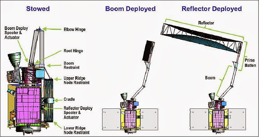
In order to get SMAP into space, the instruments team, led by Wendy Edelstein, had to be innovative with their design. They had to create a rotating radar antenna large enough to transmit the signal down to earth and receive it back in space, but small enough to fit in the second stage compartment of an Atlas model launch vehicle. To accomplish this, the instruments team created a conical scanning mesh reflector that deploys in space. It is connected to a spin platform assembly by a folding mechanical arm. Once SMAP is in orbit, the arm unfolds, the mesh is unfolded, and the spin platform assembly begins to rotate. Thus begins the journey of SMAP.
Soil Moisture Active Passive (SMAP)
During
our last visit to NASA’s JPL, we learned about their current project, SMAP.
SMAP stands for Soil Moister Active Passive. The project involves a satellite
that that will be able to scan to earth and measure the level of moisture in
soil as well as collect data on ground that is frozen versus ground that is
thawed. The foundation for SMAP was built on NASA’s previous project, Hydros.
Hydros was selected in 2002 as an alternate Earth System Science Pathfinder or
ESSP. The mission basically had the same objective as SMAP in that they both
measure soil moisture and frozen/thawed ground. In 2005, those working on
Hydros were notified that they were not going to receive the funds they needed
to finish the project due to budget cuts. Though the project was left
incomplete, they were able to use different levels from Hydros as a starting
point for SMAP. The amount of effort and progress already made on Hydros was
one of the primary reasons that SMAP was chosen by the decadal survey. Out of
over a hundred submitted missions, SMAP was one of four projects chosen for the
top Tier-1 2010-2013 launch.
SMAP has great potential to help people
all over the world. It is pretty amazing that these scientists were able to
develop the algorithms and technology to measure soil moister from space! What
is also impressive is the massive amount of people who have collaborated on
this project. So many people working on so many different aspects of the
project, yet they are all able to keep everything constant and coherent and
make sure that all parts fit and work together. SMAP will be very helpful in
the future. It will give us the ability to spot drought patterns and predict
floods and landslides. Being able to predict droughts would be very helpful to
the agricultural industry and being able to warn people of floods and
landslides could save lives. SMAP can also see what land is frozen and what land
is thawed. By tracking change in frozen/thawed land could help predict the
growing season and the seasonal rises of CO2 that come with it. This data would
also be beneficial to research on climate change. By tracking the frost
patterns each year they can tell which climates are warming up, and which ones are
cooling down. Because the data collected by SMAP will be available to any one
who wants it, there may be even ways in which that data will be useful that the
scientists behind SMAP did not even think of.
One crucial piece of equipment on
SMAP is the large antenna. The antenna is 6 meters in diameter and is made of a
reflective mesh with a parabolic shape facing earth. The parabolic shape of the
mesh spreads out signals from the radar to a larger diameter. The shape also
causes signals coming from the earth to redirect into the feed horn. In order
to send SMAP into space, they needed to make the antenna have the ability to collapse
and fold into a small space. To do this the structure of the antenna is made of
tubes with wires running through them. After the arm has fully extended the
wires are pulled in, which causes the tubes to expand out and pop into place.
In testing on earth this process takes about a half hour.
SMAP OVERLOAD
SMAP-- Soil Moisture Active Passive-- is a NASA program whose story dates back to the early 2000's. The origins of SMAP stemmed from analog style land research. Tired of surveying on foot, scientists sought to formulate other options for their teams. A plane radiometer that collected aerial footage proved to be an effective tool for conducting water content data collection and analysis. A global space mission program known as Hydros went into development in years to come. In a 2007 Decadal Survey, NASA's SMAP was granted mission funding by the National Academy for the 2010-2020 top ten projects. The program went into research, design, and lot of testing with the hopes of launching November of this year.
Erika Podest, a land flux and ecosystem scientist at JPL talked to us about her work with water and carbon cycles in northern wetlands. SMAP measures the top 5 cm of surface soil moisture and determines its frozen or thawed state. With this data Podest is able to to collect information for application in weather forecasting, plant growth and runoff data. The water cycle-- evaporation, condensation and precipitation-- is what determines the weather, which is always changing. The signals will accumulate information on different types of soil and humidity modulations that affect crop yield and agricultural production. Furthermore, the data will aid in flood, drought and hurricane forecast. SMAP will enable her to compile her research seasonal solid and liquid changes of state in northern high latitude regions more efficiently. With that, she can better understand the timeline of carbon content in the atmosphere in order to determine the viability of local vegetation. The mission vehicle has two main functional tools: a radar and a radiometer. The former measures the overall radiation emitting from earth. The latter actively sends and receives soil sensitive signals. In three days, the entire globe soil moisture content is collected. The signals fall under microwaves on the electromagnetic spectrum-- this enables them to pass through clouds, reaching up to 36 km at a time.
Throughout the entirety of SMAP's design process, form follows function. It utilizes a rocket for launch which emits carbon and noise into Earth's atmosphere. It also serves as an observatory-- a robit with the ability to take measurements and relay them back to Earth, where it is processed and archived. Designers must emphasize the need for a compact craft that is both lightweight and cost-effective. Furthermore, team members must consider the need to use materials in an out-of-the-box manner-- applying thermal reflection paint onto the radars exterior in order to protect the amplifier and RF deck from overheating, for example. One component of the mission's structure that intrigued me was the antenna's parabolic surface is able to focus the RF signal wavelengths. The parabola-- a bell like shape-- has been used in physics, art, geometry and even by the military to focus sound, heat, and light waves. SMAP is able to implement telecom features through the parabola's structure that acts like a mirror for ultrasound-like rays to be targeted. SMAP's antennae is able to collect high resolution feedback with it's radar component and radiation emission information that is of the highest accuracy.
Tuesday, March 18, 2014
Dan Goods @ JPL
Dan Goods is a "Visual Strategist" at JPL, facilitating sensory experiences of science through mediums of graphic design, sculpture, video, and various installation projects.
As a graphic designer/artist also interested in science, I was really interested to hear about Dan's experience. It was refreshing to see the possibilities of creating multidisciplinary artwork that inspires as well as educates. Dan talked about "sneaking up on learning", by developing visually stimulating installations that give viewers a "moment of awe", encouraging them to learn more about scientific subjects.
By playing to our natural human interest in beauty & mystery, and an innate curiosity for the world (& universe) around us, Dan is able to attract viewers to experience science in a way that they wouldn't be able to without an artist's interpretation. Not only does his work facilitate uncommon experiences, but it communicates information in an accessible way.
Some examples of his work here:

beneath the surface: jupiter, lightning, and invisible lights

http://directedplay.com/aerogel.html

"View looking into the magnifying glass showing the grain. It has a hole drilled into it. All the planets found outside our solar system could fit within this area of our galaxy."
http://directedplay.com/bigplayground.html
As a graphic designer/artist also interested in science, I was really interested to hear about Dan's experience. It was refreshing to see the possibilities of creating multidisciplinary artwork that inspires as well as educates. Dan talked about "sneaking up on learning", by developing visually stimulating installations that give viewers a "moment of awe", encouraging them to learn more about scientific subjects.
By playing to our natural human interest in beauty & mystery, and an innate curiosity for the world (& universe) around us, Dan is able to attract viewers to experience science in a way that they wouldn't be able to without an artist's interpretation. Not only does his work facilitate uncommon experiences, but it communicates information in an accessible way.
Some examples of his work here:
beneath the surface: jupiter, lightning, and invisible lights
http://directedplay.com/aerogel.html
"View looking into the magnifying glass showing the grain. It has a hole drilled into it. All the planets found outside our solar system could fit within this area of our galaxy."
http://directedplay.com/bigplayground.html
SMAP @ JPL


SMAP (Soil Moisture Active Passive) is JPL's current satellite mission, and the first of NASA's Earth Science Decadal Survey missions. (The Decadal Survey, conducted by the National Research Council (NRC), evaluates what the most important areas of scientific study are for the next ten years). SMAP is greatly influenced by the NASA Hydros mission, which had similar goals but was cancelled in 2005 due to a lack of funding.
SMAP was developed to gather data about the conditions of Earth's soil moisture, and how it changes through its freezing and thawing states. This information is gathered by the satellite's high-res global mapping of the top 5 cm of Earth's surface, which is measured every 3 days. The data collected can be applied to the conduction of more accurate weather forecasts, agricultural production, flood & drought warnings, human health (in terms of vector born diseases and water supply), and studies of climate change. What I found most significant about SMAP is that the data effects the whole world (and is available to the whole world) not just coveted by one governmental organization. This fact highlights the importance of facilitating a global movement to fight climate change and understand what is actually happening to our planet. The use of SMAP emphasizes our need to unite as a species and educate ourselves in order to be a positive influence on our ecosystem -- instead of blindly destroying it.
The part of the "Instrument" that I was most interested in was the antenna, which was explained to us by Wendy Edelstein. The antenna is connected to the body of the satellite with an arm that extends to support a spinning reflector. The parabolic reflector is optically transparent but can appear opaque depending on how it interacts with the light. My first impression was that the reflector looked extremely delicate, made of a mesh material that didn't look like it could withstand the conditions of outer space, (ex. encounters with rocky debris & whatever else is orbiting around earth up there). However, Wendy confirmed that JPL has conducted enough tests and experiments to conclude that the material is functional, and that possible debris interference is a risk they are willing to take. The reflector begins as a compacted structure, and expands to be 6 meters wide when released from its compartment. The expansion takes about 30 minutes. The reflector spins at 14 revolutions per minute, capturing 1000 km of land in its swath.
Sunday, March 9, 2014

Wednesday, March 5, 2014
The Oculus Rift

During our last visit to JPL, a few of our class members (me included) had the opportunity of testing out the Oculus Rift. This device is used for advanced motion tracking and has been utilized for years with video game platforms. I had to wear goggles that displayed the virtual reality and motion tracked my head movements. The combination between the goggles and the 9 motion capture cameras mounted on the ceiling placed me in a completely false, yet oddly believable, environment. JPL uses this technology to simulate Curiosity on Mars. So, the display that I saw with the goggles was a barren, red landscape.
The Oculus Rift was created in 2012 by a young inventor and designer, Sergey Orlovskiy. The company raised $91 million to fund their research, $2.4 million of which was gathered through the crowd sourcing site Kick Starter. A consumer version of the Oculus Rift will be available in 2015, with games that will be fully interactive and immersive.
 |
| Consumer version of the Oculus Rift |
 |
| the Oculus Rift at NASA (with treadmill) |
Eyes on Exoplanets
One of the many exciting things that scientists at NASA and JPL are doing is searching for stars with exoplanets. Exoplanets are planets orbiting other stars in other solar systems. To find these planets they keep a close eye on the stars. If a star they are observing dims it may mean that a planet has passed in front of it. They have confirmed 1,690 exoplanets already and with 3,845 other possible candidates that means they have discovered 5,535 possible exoplanets. These were all discovered in only a small fraction of our galaxy. The is so much more that scientists haven't even begun to search.


Using NASA’s “Eyes on Exoplanets” program you can explore
all of the exoplanets that have been discovered so far and their solar system.
With the program you can measure the distance between the earth and other
exoplanets, or even other exoplanets or stars to each other. You can also
compare the size and orbits of other solar systems to are own side by side. There
is also a feature that tells you how long it would take to get to a solar
system by various modes of transportation like by car, jet, and bullet train,
and light speed.
If you click on a planet in a solar system it will bring up
an artist rendition of the planet and a description of what scientists know
about it so far.
There is also a feature wear you click any spot on the earth
and it will show you what stars with exoplanets you can see from that spot and
which of those can be seen with the naked eye.
One planet of interest that scientist have discovered is Kepler-413b. Kepler-413b is a large, gas planet about 65 times the mass of earth. It orbits around two stars; an orange dwarf and a red dwarf. What scientists find peculiar about Kepler-413b is that it is wobbling as it orbits. The tilt of the planet keeps changing. This would cause the seasons on this world to be erratic and constantly changing. They have also observed that the planet's orbit tilted so they cannot always see when it has completed another orbit.

One of the coolest parts of the search for exoplanets is when they find planets similar to earth that could retain water in its liquid form and possibly sustain life. The idea that some of these worlds could have life on them or even other sentient beings is incredible to think about.
All information in this post can be found at NASA's JPL website.
Subscribe to:
Posts (Atom)